
New York Harbor, one of the world’s busiest and most strategically vital ports, has been protected by a remarkable network of fortifications for more than two centuries. From the American Revolution through the World Wars, these forts formed a defensive ring around the city, deterring invasion and safeguarding its people and commerce. This guide explores the history, architecture, and enduring legacy of New York’s harbor forts—many now open to the public as museums, parks, and national monuments. Discover where to visit, what to see, and how these iconic structures shaped the destiny of America’s greatest city.


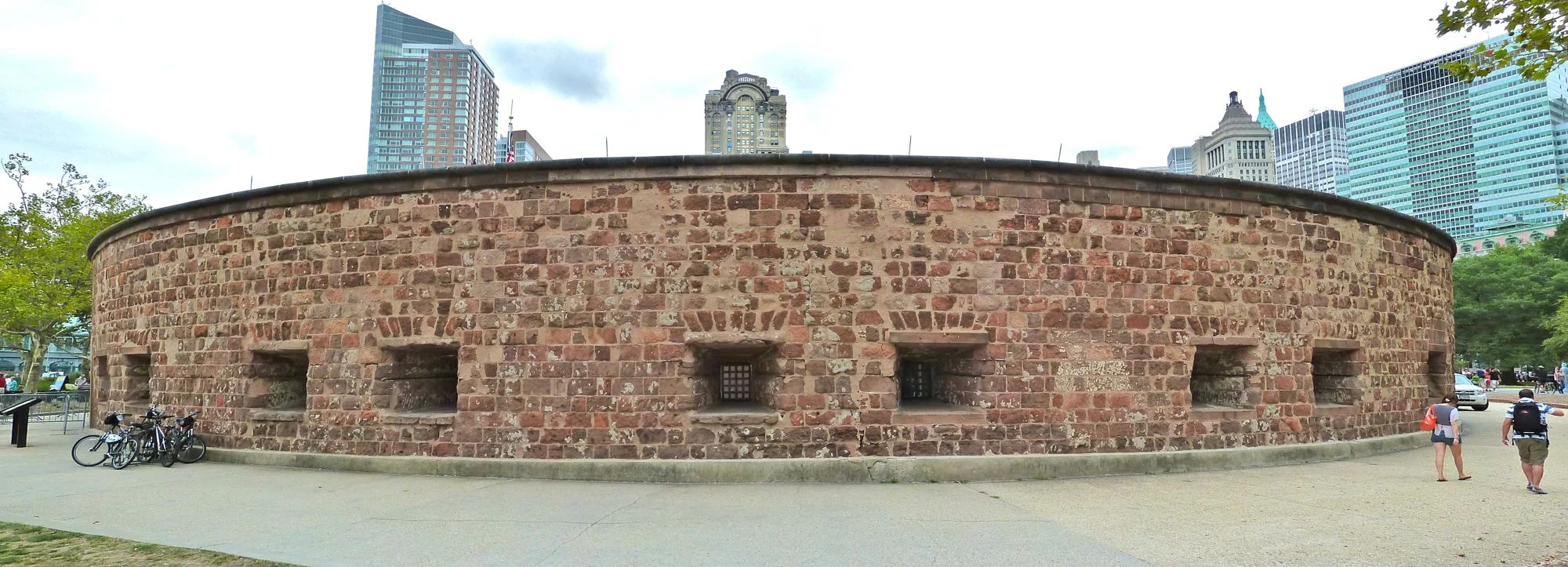
Castle Clinton
Battery Park, Lower Manhattan, New York
Built: 1808–1811
Current Use: National Monument / Museum
Contact: National Park Service (NPS) – 212-344-7220 | nps.gov/cacl
Castle Clinton is a circular sandstone fortification at the southern tip of Manhattan in Battery Park, originally constructed as part of New York’s harbor defenses. Over its long history, it has served many roles—from a military fort to a concert hall, immigrant processing center, and aquarium—before becoming a national monument and museum.
Historical Significance
Designed by John McComb Jr. and engineered by Jonathan Williams, Castle Clinton was initially known as the Southwest Battery and built on a rocky outcrop about 300 feet offshore. Completed by 1811, it was armed with 28 cannons but never saw combat during the War of 1812. After the war, it was renamed in honor of Mayor (and later Governor) DeWitt Clinton. The fort was linked to Manhattan by a wooden bridge and, as land was filled in, eventually became part of the expanding Battery area.
The U.S. Army ceased using the fort in 1821, and it was transferred to New York City in 1823. The structure was then adapted for public use, first as an entertainment venue called Castle Garden, and later as America’s first official immigration station, processing over 8 million newcomers before Ellis Island took over that role in 1890. In the late 19th and early 20th centuries, Castle Clinton became the original home of the New York Aquarium, one of the city’s most popular attractions until it closed in 1941.
Features
Today, Castle Clinton is the centerpiece of Battery Park. It houses museum exhibits that tell the story of its diverse past, serves as a ticket office for ferries to the Statue of Liberty and Ellis Island, and hosts live performances and special events. The National Park Service maintains the site, offering guided tours and educational programs.
Note: Ongoing or upcoming renovations may include restoration of the fort’s roof and the possible addition of a second level to enhance visitor experience and preserve the structure for future generations.
Getting There
Subway:Take the 1 train to South Ferry.

Castle Williams
Governors Island National Monument, New York Harbor, Manhattan
Built: 1807–1811
Current Use: National Monument
Contact: National Park Service (NPS) – 212-514-8271 | nps.gov/gois
Castle Williams stands as a striking circular fortification of red sandstone on the western edge of Governors Island. Designed and constructed by Lieutenant Colonel Jonathan Williams—the first superintendent of the United States Military Academy at West Point and a relative of Benjamin Franklin—the fort is celebrated as one of the earliest examples of casemate-style fortification in North America. Its robust, castle-like appearance and pioneering design made it a prototype for coastal defenses across the United States.
Historical Significance
Castle Williams was a key component of the Second American System of coastal defense, built to protect New York Harbor from naval threats, particularly during the War of 1812. Alongside Fort Jay and the South Battery on Governors Island, Castle Clinton in Manhattan, Fort Wood on Liberty Island, and Fort Gibson on Ellis Island, it formed a network safeguarding the city’s vital harbor. Despite its formidable armament—including multiple tiers of gun casemates—the fort never saw combat.
By the 1830s, Castle Williams was considered obsolete for military defense and was repurposed as barracks for troops. During the Civil War, it became a prison for Confederate soldiers, and in later years, it served as a military prison for U.S. soldiers, including World War II recruits who attempted to go AWOL. The fort’s adaptability continued as it was later used for community activities before finally becoming a historic landmark.
Architectural Features
- Design:Circular, 40 feet high and 210 feet in diameter, with walls up to 8 feet thick.
- Armament: Originally equipped with multiple tiers of cannons—27 French 35-pounders on the lower tier and 39 20-pounders on the second tier (note: some sources suggest 13 casemates per level with variable armament; specifics may have varied over time).
- Casemates: Three or four levels of reinforced gun chambers (casemates), a design innovation that influenced future American forts.
Features
Castle Williams is now part of Governors Island National Monument and is open to the public for tours and special events. The National Park Service has stabilized the structure and, when possible, offers access to the roof, providing panoramic views of New York Harbor and the city skyline. The fort is listed on the National Register of Historic Places and is a contributing feature within a National Historic Landmark District.
Getting There
- Ferry: Take the Governors Island Ferry from the Battery Maritime Building in Lower Manhattan.

Fort Gibson
Ellis Island, New York Harbor, Manhattan
Built: 1807–1811 (main stone/brick fort; earlier wood/sod structure in 1794)
Current Use: National Monument / Museum (part of Statue of Liberty National Monument)
Contact: National Park Service (NPS) – 212-363-3200
Fort Gibson stands as a reminder of Ellis Island’s military past, long before it became renowned as America’s gateway for immigrants. Located at the southeast end of Ellis Island, the fort’s archaeological remains tell the story of nearly a century of harbor defense, from the early days of the Republic through the Civil War.
Historical Significance
Ellis Island’s military history began in 1794 with the construction of a crescent-shaped wood and sod fort, built to protect New York Harbor from potential threats. Between 1807 and 1811, this structure was replaced by a more substantial stone and brick fort, designed to meet the standards of the Second System of coastal fortifications. The fort was officially named Fort Gibson in 1814, honoring Colonel James Gibson, a hero killed during the War of 1812 at the Siege of Fort Erie.
Fort Gibson was armed with approximately 13 cannons and could garrison up to 182 soldiers. Although it never saw combat, it served as a barracks for American troops and as a prison for British soldiers during the War of 1812. After the war, the fort continued in use as a recruiting depot and later, during the Civil War, as a munitions arsenal and supply base for the Union Army. The fort’s magazine was expanded to accommodate the Navy’s gunpowder stores, which were considered too hazardous to keep in Brooklyn.
By the late 19th century, as the need for harbor fortifications waned, the fort was largely dismantled, and the island transitioned to new roles, first as a naval ordnance depot and then as the nation’s primary immigration station.
Features
Today, the remnants of Fort Gibson are visible at the southeast end of Ellis Island. Archaeological excavations have revealed portions of the fort’s stone and brick walls, which are now highlighted as part of the island’s interpretive experience. These remains serve as a tangible link to New York’s military heritage and are accessible to visitors touring the Ellis Island National Museum of Immigration.
Getting There
- Ferry: Take the Statue of Liberty Ferry from Battery Park (Manhattan) or Liberty State Park (New Jersey) to Ellis Island.
- On-Site: Fort Gibson’s archaeological site is located near the American Immigrant Wall of Honor.

Fort Hamilton
The Narrows, Brooklyn, New York
Built: 1825–1831
Current Use: Active Army Post / Museum
Contact: 718-630-4349
Fort Hamilton is a historic United States Army installation located at the eastern side of the Verrazzano-Narrows Bridge in Brooklyn. As one of the nation’s oldest continuously garrisoned military posts, Fort Hamilton stands as a living link to America’s coastal defense heritage and remains an active base for Army Reserve, National Guard, and recruiting units today
Historical Significance
The strategic importance of Fort Hamilton’s location was recognized as early as July 4, 1776, when American forces under General Henry Knox fired upon the British ship HMS Asia from a small battery at this site—an early act of defiance in the Revolutionary War. Although the attack was largely symbolic, it marked the beginning of the site’s long military history.
Following the War of 1812, the need for robust coastal defenses led to the construction of a new granite fort, designed by Simon Bernard, a former French military engineer. Construction began in 1825, with the cornerstone laid on June 11 of that year, and the fort was completed in 1831.The original structure, known as the Casemate Fort or Whiting Quadrangle, featured two tiers of cannon, thick granite walls, and innovative defensive features such as caponiers and a dry ditch.
Fort Hamilton was named in honor of Alexander Hamilton, the first U.S. Secretary of the Treasury and a Revolutionary War hero—though the naming may have occurred later in the fort’s history. Over the years, the fort has hosted notable military figures, including Robert E. Lee, who served as post engineer, and Thomas “Stonewall” Jackson and Abner Doubleday, both of whom were stationed here.
During the Civil War, Fort Hamilton played a role in protecting New York Harbor from Confederate raiders and contributed troops to help quell the New York City draft riots of 1863. The fort continued to serve as a vital military installation through both World Wars and remains active to this day.
Features
Today, Fort Hamilton is a bustling Army post, home to various Reserve, National Guard, and recruiting units. The fort’s historic core—the Casemate Fort—is open to the public as part of the Harbor Defense Museum, where visitors can explore exhibits on coastal defense, military history, and the fort’s storied past. The museum features an extensive collection of weapons, uniforms, and artifacts, including displays on the Battle of Brooklyn and the fort’s role in American conflicts.
While much of the original fort has been altered or demolished over time, the surviving sections offer a fascinating glimpse into early 19th-century military engineering and the evolution of coastal defense.
Getting There
- Subway: Take the R train to 95th Street, Bay Ridge, then walk or take a short bus ride to the fort.
- By Car: Fort Hamilton is accessible via the Belt Parkway and is located just east of the Verrazzano-Narrows Bridge.
- Note: As an active military installation, certain areas are restricted, but the Harbor Defense Museum and historic core are open to the public.

Fort Jay
(Fort Columbus)
Governors Island, Manhattan
Built: 1794 (earthworks); rebuilt 1806–1809 (stone fort)
Current Use: National Monument
Contact: National Park Service (NPS) – 212-514-8271 | nps.gov/gois
Fort Jay stands atop the highest point of Governors Island, offering commanding views of New York Harbor and the Manhattan skyline. This historic fortification is a prime example of early American military engineering and a key part of Governors Island National Monument. Surrounded by earthen-covered walls and a distinctive star-shaped dry moat, Fort Jay is a well-preserved reminder of the city’s coastal defense history.
Historical Significance
The site’s military roots trace back to the American Revolution, when Continental troops constructed earthen fortifications in 1775–1776 to defend New York Harbor. After the war, the works fell into disrepair until renewed tensions with European powers prompted reconstruction in 1794. The fort was named for John Jay, a Founding Father, New York governor, and the first Chief Justice of the United States.
In 1800, Governors Island and its fort were transferred to the federal government. Between 1806 and 1809, the earthworks were replaced with granite and brick walls, a dry moat, and a glacis designed by Major Jonathan Williams, chief engineer of the U.S. Army Corps of Engineers. During this period, the fort was renamed Fort Columbus—possibly in honor of Christopher Columbus—and served as a key defensive post during the War of 1812.
The fort’s name reverted to Fort Jay in 1904, reflecting its original namesake. Throughout the Civil War, Fort Jay was armed with Rodman cannons, several of which remain on site today as historical artifacts. During World War II and its aftermath, the fort served as the headquarters for the First U.S. Army, which played a pivotal role in the D-Day landings at Normandy. The Army maintained its presence until 1966, after which the Coast Guard took over until 1996.
Architectural Features
- Design: Star-shaped dry moat and earthen-covered walls for blast protection.
- Materials: Granite, brick, and sandstone, with later modifications in brick for barracks and support buildings.
- Cannons: Three original Rodman cannons from the Civil War era are still mounted on the ramparts.
- Location:The fort occupies the highest ground on Governors Island.
Features
Today, Fort Jay is operated by the National Park Service and is open to the public. Visitors can explore the fort’s grounds, walk the ramparts, and view the historic cannons. The site is a highlight of any visit to Governors Island, offering both historical insight and panoramic vistas.
Getting There
- Ferry: Take the Governors Island Ferry from the Battery Maritime Building in Lower Manhattan.

Fort Lafayette
The Narrows, Brooklyn, New York
Built: 1812–1822 (construction began during the War of 1812, completed in 1822)
Current Use: Site now occupied by the Brooklyn tower of the Verrazzano-Narrows Bridge
Fort Lafayette once stood as a formidable island coastal fortification in The Narrows of New York Harbor, just offshore from what is now the Bay Ridge neighborhood of Brooklyn. Built on Hendrick’s Reef, the fort was an integral part of the city’s harbor defense system for over a century before being demolished to make way for the Verrazzano-Narrows Bridge.
Historical Significance
Construction of Fort Lafayette began in 1812, spurred by the outbreak of the War of 1812 and the need to bolster New York’s coastal defenses. The fort was originally named Fort Diamond for its diamond-shaped design, but in 1823 (or 1825, according to some sources), it was renamed in honor of the Marquis de Lafayette, the French hero of the American Revolution, ahead of his celebrated tour of the United States.
Fort Lafayette was constructed of brick and sandstone, with thick walls and a central courtyard. Its design allowed for three tiers of artillery—about 72 cannons in total—providing overlapping fields of fire to protect the harbor entrance. The fort never saw combat, but its presence served as a powerful deterrent to would-be attackers.
During the American Civil War, Fort Lafayette gained notoriety as a military prison for civilians deemed disloyal to the Union, earning the nickname “American Bastille”. After the war, the fort was adapted for use as a naval magazine and ammunition depot, serving in this capacity from 1898 until the end of World War II.
Legacy and Demolition
With the advent of modern warfare and changing military needs, Fort Lafayette was eventually abandoned. In 1960, the fort was razed to provide a foundation for the Brooklyn tower of the Verrazzano-Narrows Bridge, one of the great engineering projects of mid-20th century New York. Today, only the massive bridge tower marks the location where the fort once stood.
Location: The former site of Fort Lafayette is now occupied by the eastern (Brooklyn) tower of the Verrazzano-Narrows Bridge.

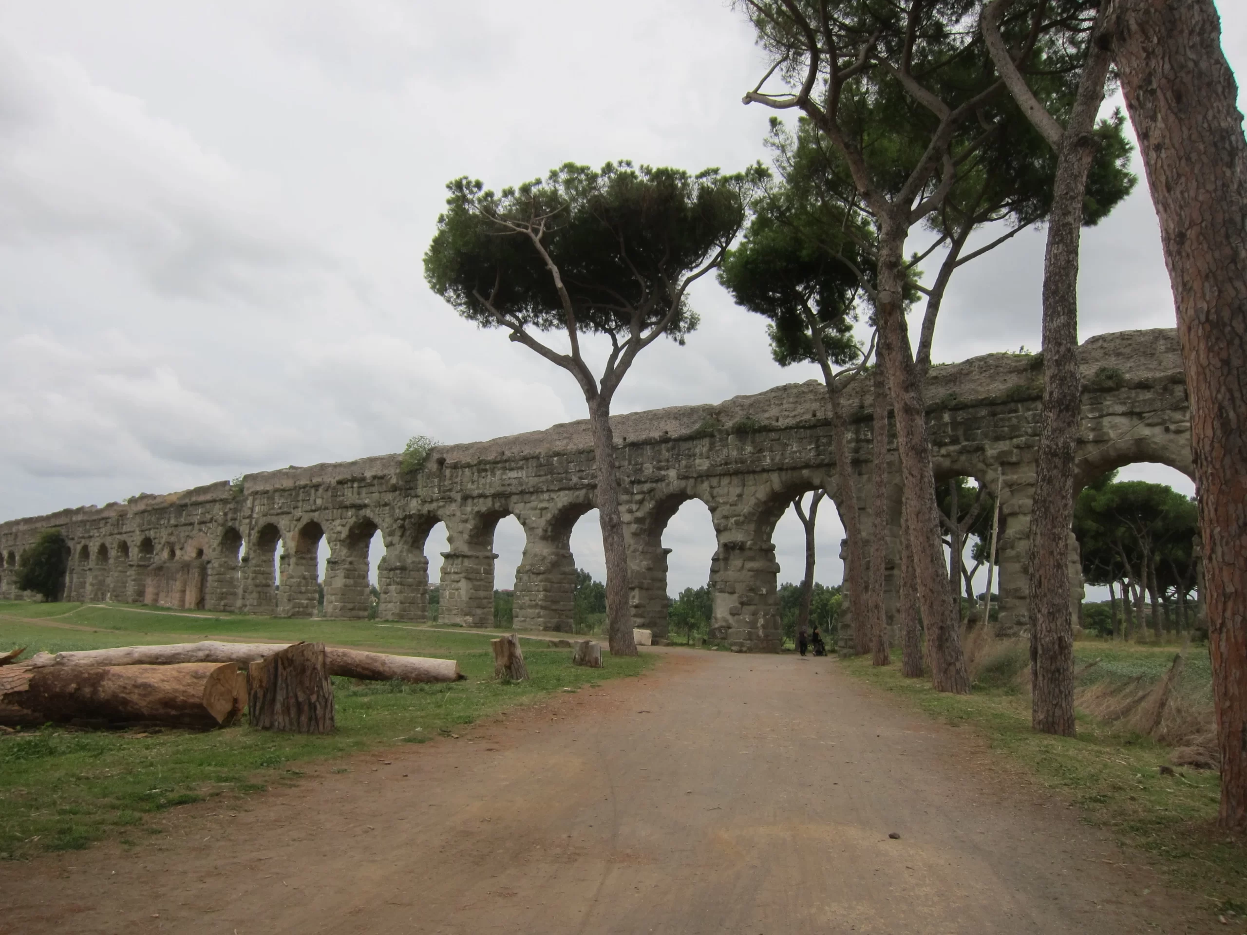
Fort Schuyler
Throgs Neck, Bronx, New York
Built: 1833–1856 (construction began in 1833; dedicated in 1856 at 75% completion; garrisoned 1861)
Current Use: Maritime College / Museum
Contact: 212-409-7218
Fort Schuyler stands as one of the finest surviving examples of 19th-century coastal defense architecture in the United States. Located at the southeastern tip of the Bronx, where the East River meets Long Island Sound, the fort was strategically positioned to protect New York City from naval attack by closing off the western end of the Sound. Today, Fort Schuyler is the centerpiece of the State University of New York (SUNY) Maritime College campus and is open to the public as a museum and educational landmark.
Historical Significance
Fort Schuyler was conceived in the wake of the War of 1812, when the vulnerability of America’s coastline became evident. Construction began in 1833 under the direction of the U.S. Army Corps of Engineers, with Captain I.L. Smith credited as the main architect. The fort is constructed of granite, much of it quarried in Greenwich, Connecticut, and features an irregular pentagonal shape inspired by French military engineering.
At its peak, Fort Schuyler could accommodate a garrison of 1,250 soldiers and was armed with up to 312 seacoast and garrison guns, making it one of the most formidable coastal forts of its era. The fort’s design included three tiers of artillery on its four seacoast fronts, with additional bastions and a hornwork to protect against land assault. Its defenses were complemented by Fort Totten, located across the East River in Queens, creating a powerful bottleneck for any hostile fleet attempting to approach New York Harbor.
The fort was officially garrisoned in 1861 and played a role in the Civil War, including housing Confederate prisoners of war. During the Spanish-American War, mines were laid in the waters between Fort Schuyler and Fort Totten to further secure the approach to the city.Modernization during the Endicott Period brought additional coastal artillery, but by 1934, the fort was decommissioned and transferred to the State of New York.
Features
Since 1934, Fort Schuyler has been home to the SUNY Maritime College. The fort has been carefully restored and now houses the Maritime Industry Museum, which features exhibits on maritime history, naval architecture, and the fort’s own storied past. The site is listed on the National Register of Historic Places and is open to the public for tours and educational programs.
Getting There
- Subway and Bus: Take the 6 train to Westchester Square, then transfer to the Bx40 bus. The Bx40’s last stop is at SUNY Maritime College, directly at the fort.
- By Car: The campus is accessible via the Throgs Neck Expressway and local roads; limited parking is available.

Fort Tilden
Rockaway Peninsula, Queens, New York
Established: Construction initiated in 1917, with key structures completed by the 1920s
Current Use: National Park (Gateway National Recreation Area)
Contact: National Park Service – 718-318-4300
Located on the Rockaway Peninsula in Queens, Fort Tilden is a sprawling site where history and nature intertwine. Spanning over 300 acres, this former military post honors Samuel J. Tilden, a notable New York governor and presidential contender. Originally developed for coastal defense during the First World War, Fort Tilden evolved into a vital component of New York Harbor’s protection network.
Historical Significance
Fort Tilden’s military past is marked by its partnership with Fort Hancock, across the water in New Jersey, forming a defensive line for the city’s harbor. Its formidable batteries—including Battery Harris, equipped with massive 16-inch guns—stood guard for decades. During the Cold War, the site adapted to new threats, hosting anti-aircraft installations and, later, Nike missile batteries tasked with defending the skies above New York.
After its military life, Fort Tilden transitioned to civilian use in 1974, joining the Gateway National Recreation Area. While some areas remain off-limits for safety, much of the fort is open for exploration, offering a rare glimpse into both its strategic history and the resilience of nature.
Features
Today, Fort Tilden is a haven for wildlife and outdoor enthusiasts. Its trails wind through maritime forests, past dunes and salt marshes, and alongside the remains of old batteries and gun emplacements. Many of these structures now serve as observation points for birdwatchers, who flock here to spot raptors and migratory shorebirds. The site is also recognized for its role in protecting rare nesting birds such as piping plovers.
Visitors can hike, fish, or simply relax on the quiet beaches, all while surrounded by the echoes of the past.
Getting There
- By Subway and Bus: Take the A train to Rockaway /Beach 116th Street, then transfer to the Q35 Green bus toward Fort Tilden.
- By Ferry: The NYC Ferry offers service to Rockaway from Manhattan, with connecting bus routes.

Fort Totten
Willets Point, Queens, New York
Built: 1858 (construction began; major works completed by the Civil War era)
Current Use: Public Park/Historic Site
Contact: NYC Parks – 718-352-4793 | nycgovparks.org
Fort Totten stands as a striking reminder of New York City’s military heritage, poised at Willets Point in northeastern Queens. Constructed in the mid-19th century to defend the “back door” of New York Harbor, the fort was originally known as the Fort at Willets Point before being renamed in honor of General Joseph Gilbert Totten, a distinguished Chief Engineer of the U.S. Army.
Historical Significance
Strategically situated across the East River from Fort Schuyler in the Bronx, Fort Totten played a crucial role in the city’s coastal defense system. Its mission was to guard against naval attack from the Long Island Sound. Throughout its long service, the fort evolved with changing military needs, hosting artillery batteries, submarine mines, and, during the Cold War, serving as a research and development center for the Nike missile defense system.
For much of the 20th century, Fort Totten was a key educational hub for the Army Corps of Engineers, with the historic 1870 Officer’s Club building remaining a proud symbol of their presence. The site continued as a military staging and support facility through the Gulf War era before being transferred to civilian use.
Features
Today, Fort Totten is a popular public park managed by NYC Parks. Visitors can explore its grassy fields, scenic waterfront views, and a wealth of preserved historic structures. The landmark Officer’s Club, with its distinctive architecture, remains a focal point and is still associated with the Army Corps of Engineers. The site also features walking paths, open spaces for recreation, and opportunities for birdwatching and photography.
Getting There
- Long Island Rail Road (LIRR): Take the LIRR to Bayside Station, then use local bus or taxi services to reach Fort Totten.
- By Bus: Several MTA bus lines serve the area, including the Q13 and Q16.
- By Car: Accessible via Cross Island Parkway and local streets; limited on-site parking available.

Fort Tryon Park (Fort Washington)
Hudson River, Upper Manhattan, New York
Built: 1776 (as part of Fort Washington defenses)
Current Use: New York City Park
Contact: nycgovparks.org
Fort Tryon Park, rested on the bluffs overlooking the Hudson River in Upper Manhattan, is a scenic park with deep historical roots. The land was originally known to the Lenape as Chquaesgeck and to Dutch settlers as Lange Bergh (Long Hill), but it is best remembered for its role in the American Revolution as part of the Fort Washington defenses.
Historical Significance
During the Revolutionary War, the area was a key strategic site for the Continental Army. In 1776, American forces constructed fortifications here as an outlying defense for Fort Washington, which lay about a mile to the south at what is now Bennett Park. On November 16, 1776, the Battle of Fort Washington took place. Despite a determined stand, the American garrison was overwhelmed by British and Hessian troops, marking a significant defeat for the patriots.
The site became famous for the heroism of Margaret Corbin, who took up her fallen husband’s position at a cannon and became the first American woman known to have fought and been wounded in combat. Her bravery was later recognized by Congress, which granted her a pension in 1779—a rare honor for a woman at the time. After the British victory, they renamed the site “Fort Tryon” in honor of Sir William Tryon, the last British governor of colonial New York. The name persisted even after the war, as the area became part of New York’s evolving landscape.
Features
Today, Fort Tryon Park is a beloved urban oasis. Designed by the Olmsted Brothers and gifted to the city by John D. Rockefeller Jr., the park opened in 1935 and features expansive lawns, winding paths, and the renowned Heather Garden. The Cloisters, a branch of the Metropolitan Museum of Art, is located within the park and houses an exceptional collection of medieval European art.
Getting There
- Subway: Take the A train to 190th Street, which provides direct access to the park’s main entrance at Margaret Corbin Circle.
- By Bus: Multiple MTA bus routes serve the area.

Fort Wadsworth
The Narrows, Staten Island, New York
Key Structures:
- Fort Tompkins: Built 1807 (current masonry fort completed mid-19th century)
- Battery Weed: Built 1860
- Fort Wadsworth: Name applied to the larger complex, with origins tracing to Dutch fortifications in 1636
Current Use: National Park (Gateway National Recreation Area)
Contact: National Park Service (NPS) – 718-354-4500
Fort Wadsworth stands as a sentinel at the entrance to New York Harbor, guarding the strategic Narrows between Staten Island and Brooklyn. The site is renowned as the oldest continuously manned military installation in the United States, with its roots stretching back to Dutch colonial times.
Historical Significance
The area was first fortified by the Dutch in 1636. Over the centuries, it played a pivotal role in every major American conflict from the Revolutionary War through the Cold War. During the Revolutionary War, the site was occupied by British forces, who strengthened its defenses. In the War of 1812, the United States enlarged the fortifications, aiming to protect New York City from British naval attack.
The current masonry Fort Tompkins was completed in the mid-19th century, while Battery Weed, a massive granite fortification, was finished in 1860. Together, these structures formed a formidable defense system. The complex was named Fort Wadsworth in the late 19th century, in honor of Brigadier General James Wadsworth, who died in the Civil War.
Features
Fort Wadsworth is actually a collection of several forts and batteries, each with its own history and architectural style. Visitors can enjoy a fascinating combination of historic fortifications, scenic views, and recreational opportunities, managed by the National Park Service as part of Gateway National Recreation Area. The park offers guided tours, special events, and educational activities.
Getting There
- Public Transit: Take the Staten Island Ferry from Manhattan to St. George Terminal, then board the S51 bus to Fort Wadsworth.
- By Car: Accessible via the Verrazzano-Narrows Bridge or local roads; parking is available on-site.

Fort Wood
Liberty Island, New York Harbor, New York
Built: 1808–1811 (construction began as early as 1806; major work completed by 1811)
Current Use: National Monument (Base of the Statue of Liberty)
Contact: National Park Service (NPS) – 212-363-3200 | nps.gov/stli
Fort Wood stands as a unique piece of American military architecture, now famous as the foundation for the Statue of Liberty. Built in the shape of an eleven-pointed star, the fort was designed following French military engineering traditions introduced to North America in the 17th century. Its robust granite and masonry walls were constructed to withstand assault and provide overlapping fields of fire for its artillery.
Historical Significance
Originally known as Bedloe’s Island, the site was ceded to the federal government in 1800 specifically for military fortification. Fort Wood was a key link in the chain of defenses protecting New York Harbor, mounting up to 24 guns and serving as a lookout and artillery position during the War of 1812. The fort was later named in honor of Lieutenant Colonel Eleazer Derby Wood, a New York-born engineer who died in the Siege of Fort Erie during the War of 1812.
Over the decades, Fort Wood’s role evolved: it became an Army Recruit Depot in 1851, housed barracks and support buildings, and was repurposed during the Civil War as a recruiting and hospital facility. By the late 19th century, the fort was considered obsolete for military purposes.
From Fort to Monument
In 1886, the Statue of Liberty was erected atop the remains of Fort Wood, with the statue’s pedestal built directly into the fort’s walls. The fort’s 20-foot-thick granite walls and original sally port now form the entrance to the statue’s pedestal. Inside, visitors can climb stairways to a promenade that was once a gun platform along the fort’s ramparts.
Visiting Fort Wood
Today, Fort Wood is open to the public as part of the Statue of Liberty National Monument. Visitors can explore the remnants of the star-shaped walls, view interpretive exhibits, and enjoy panoramic views of New York Harbor. The site is a blend of military history and national symbolism, offering a tangible connection to America’s past.
Getting There
- By Ferry: Access Liberty Island via the official Statue of Liberty Ferry from Battery Park (Manhattan) or Liberty State Park (New Jersey).
- All visitors must pass through security screening before boarding the ferry.
post a comment cancel reply
You must be logged in to post a comment.


